| |
|
 |
|
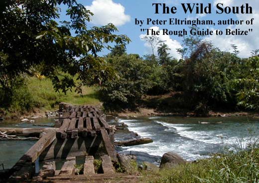
To
the south of Belmopan Belize really is at its wildest. Here the
central area is dominated by the Maya Mountains, sloping down
to the coast through a series of forested ridges and valleys carved
by sparkling rivers. As you head further south the climate becomes
more humid, promoting the growth of dense rainforest, rich in
wildlife. The forests here have evolved to cope with periodic
hurricanes sweeping in from the Caribbean and have in the past
been selectively logged for mahogany. The coastal strip south
of Belize City is a band of savannah, swamp and lagoon. Large
stands of Caribbean pine grow in the nutrient-poor savannah soils,
looking strangely out of place in the tropics. Beyond Dangriga
the shoreline is composed of sandy bays, peninsulas and mangrove
lagoons. In the far south the estuaries of the slow-moving Temash
and Sarstoon rivers, lined with the tallest mangrove forest in
Belize, form the country's southernmost national park, adjoining
protected land in Guatemala.
Population density in this part of Belize is low, with most of the towns and villages located on the coast. Dangriga, the largest settlement, is the home of the Garífuna people -descended from Carib Indians and shipwrecked, enslaved Africans - and allows access to a number of idyllic cayes, such as Tobacco Caye and South Water Caye, each with a range of places to stay. These cayes sit right on top of the barrier reef, and form the focus of South Water Caye Marine Reserve which protects a vast area of sea stretching from just south of Dangriga almost to Placencia. The villages of Gales Point, on Southern Lagoon, north of Dangriga, Sittee River and Hopkins, on the coast to the south, are worth visiting to experience their tranquil way of life. Further south, the Placencia peninsula has become established as the focus of coastal tourism in southern Belize. Based here you can visit Laughing Bird Caye National Park, the stunning Silk Cayes beyond, just inside the reef, and beyond them the unique Gladden Spit Marine Reserve, the only sanctuary on the planet established specifically to protect whale sharks - the largest fish in the world. lnland,
the Maya Mountains remain unpenetrated by roads, forming a solid
barrier to land travel except on foot or horseback. Successive
Belize governments, showing supreme foresight, have placed practically
the entire mountain massif under some form of legal protection,
whether as national park, nature reserve, wildlife sanctuary or
forest reserve. The most accessible area of this rainforest, though
still little visited by tourists, is the Cockscomb Basin Wildlife
Sanctuary, a reserve designed to protect the sizeable jaguar population
and a perfect base for exploring the forest. You'll come across
plenty of tracks - but don't count on seeing a jaguar. The Sanctuary
is also starting point for the Victoria Peak Trail - an arduous
but rewarding trek to the summit of the second highest mountain
in Belize. The newly-paved Southern Highway comes to an end in
the sleepy coastal town of Punta Gorda, from where you can head
south to Guatemala or visit Maya villages and ruins in the southern
foothills of the Maya Mountains. |
|
Here and there are small settlements of Mennonites, a religious group similar in many ways to the Amish of Pennsylvania, who are industrious and successful farmers. Although some have adopted a modern way of life and use motor vehicles and electricity, you'll still see Mennonite families wearing severe-looking pioneer-style homespun clothing, the women with long skirts and bonnets and the men bib-and-braces overalls and straw hats, driving horse-drawn buggies. At first glance a visit to the slow-paced Creole village of Gales Point is like a journey back in time, yet the skills of local drum makers and players are so much in demand overseas that they're quite familiar with North America and Europe. Placencia too is a relaxed Creole village, and as you'd expect it's a fishing village, though nowadays almost all the inhabitants are also involved in tourism and more likely to be taking you sport fishing than baiting a hook for a catch to sell in the market. The Garífuna village of Hopkins was also until recently a fishing and subsistence farming community, but its location on a long sweep of beach has made it a magnet for laid-back tourism. Garífuna culture is still very much alive however, and everyone speaks the Garífuna language. Drumming and dancing are universally popular - sensual, sensational Punta Rock is the Garífuna national dance. You'll be encouraged to take part yourself; energizing, exhausting and utterly enjoyable. The first Maya village you're likely to encounter is Maya Centre, right on the Southern Highway at the entrance to the Jaguar Reserve. The villagers here are among the few genuine practitioners of the concept of "ecotourism" and are without doubt the best guides to the reserve. As you head further south, into Toledo District, you'll come across the main region of Maya villages in Belize. Here are Mopan Maya from Petén and Kekchí Maya from the Verapaz highlands of Guatemala. For the most part each group keeps to its own villages, language and traditions, although there are mixed communities. Both groups are partially integrated into modern Belizean life and most Maya can speak English (or Creole) to outsiders. Along the last stretch of the Southern Highway and in Punta Gorda are some of Belize's East Indian communities. The ancestors of these people were originally brought to Belize from India as indentured labourers. Most stayed here when their term of indenture was over and today they are fully integrated into Belizean society, with almost no vestiges of their Indian culture remaining. Heading South. Once remote and way off the main
tourist routes, Southern Belize is now very accessible. Flying
is convenient but relatively expensive - though you do enjoy
great views of the coast and cayes. The domestic airlines, Maya
Island Air and Tropic Air, each have four or five daily flights
from Belize City to Dangriga, Placencia and Punta Gorda. Using a rental car in the south is now much easier, and you can drive from Belize City or San Ignacio to Punta Gorda in around 3 ½ hours. Having your own car will also make getting around in the far south easier too. Most of the Maya villages are connected to the Southern Highway by unpaved roads and also have a basic bus service from Punta Gorda, though this only runs on market days and there's no service on Sundays. At the time of writing the only unpaved section of the Southern Highway is a nine-mile stretch from Golden Stream Bridge to Big Falls village, and work has already begun to prepare for this for paving. At the same time the road heading west through the Maya villages from the Southern Highway at "Dump" junction, 15 miles from Punta Gorda, will be paved to the Guatemalan border. There will also be a new border crossing and the potential for tourists and business visitors to enter Southern Belize directly rather than needing to travel up through Petén to the Melchor border. Now almost certain to go ahead, this is nonetheless a controversial proposition, as some Maya communities feel they will be marginalized as international developers follow in the wake of the highway. copyright
Peter Eltringham peter.eltringham@ukonline.co.uk 2003 |