previous page
next page
 
 
A local Maya man points out a fallen stelae at the Maya site Uxbenka near San Antonio, Toledo, Belize.
 
   
It was a sun-blistering day even by Belizean standards. The usually wet western part of the Toledo District was bone dry. In fact, there had not been a drop of rain to measure in over two months and wildfires were starting to rip through the district with each gust of wind. With that in mind, I decided that it was optimum conditions to head west. So I decided that there was no better time than the present, therefore I packed a light lunch and loaded up with several bottles of water, put my knee-high Hunter rubber boots in the back of my pick-up truck along with my machete, and hit the road for the westerly route up the Southern Highway. After a quick stop at the last fuel station west of the southern Belize town of Punta Gorda, I was finally on my way.

After the crossing the locals refer to as 'the dump', the pavement turns to dirt and the dry conditions made for a dusty ride. But this was an adventure to one of the less than popular Belize Maya archaeological sites in the Toledo Dustrict and surly in time the rains would return again to wash away the miles off my aging Toyota. Undistracted, from the last refuelling station at 'the dump', the road was straight and narrow. Occasionally a truck passed, then there was the right hand turn that required on my hand scribbled map to pass that leads to the village of San Pedro Columbia that I knew not to take.


Covered by dense jungle, the remains of the Maya settlement only become visible once you stand right on front of them.
 
 
This might be the entrance to an underground room. There is a lot more to be discovered at the unexcavated Maya site of Uxbenka in Belize's Toledo ditrsict.
   
The next big decision regarding which was to go dictated that once I arrived into the village of Mafredi where there would be an intersection where choices had to be made, turn left for Blue Creek or right for towards San Antonio village. The right turn was the correct choice and soon after making it the road twisted and turned me and my old truck up and over the foothills of the lower Maya Mountains.

Soon after we were in the center of the village of San Antonio where the road turned even steeper. As I passed the infamous San Antonio waterfalls the drought was ever so evident, for there was no water whatsoever flowing over the rocks. I continued on until I reached the village of Santa Cruz. Passing through the remote village defined by a handful of thatch roofed huts on either side of the road I knew it was time to stop and ask for directions as I passed the last house.

Now it was right then and there that I realized my map was littered with errors. Though once before I had contacted the mapmaker with one mistake I had discovered, all they did via an email from the President of the company was to threaten me with litigation if I ever mentioned exactly which (Canadian) map company they were and so I understood crystal clear that we live in an imperfect world, and cartography is definitely no different.

So lost on the only road that passes through the village of Santa Cruz I looked desperately for anyone that might be able to re-direct in the correct directions towards the Uxbenka site. Generally in Maya villages during the day the men are all away working their collective fields, and the women rightfully so hide behind the wood frame houses and thatch roofed champas that make-up the village. This particular day luck was on my side, for after I had turned around twice in confusion in the center of the village of Santa Cruz, a local man named Lester Cal came out of the cool shade embracing his hammock to tell me politely, without ever coming close to mentioning a word about a guides fee to proclaim, "You look lost, can I help??"


A mound at Uxbenka

 
Indeed, this spontaneous weather driven explorer needed help from anywhere he could get it. And so in less time that you could say Uxbenka, Lester was in my old truck with his own sharpened machete wearing his own rubber boots. And though I have sadly had to change my ever important guide's name due to the reality that he is not legally licensed within the country of Belize to guide a gringo to where he needs to go, all the same, Lester to me back down the road I has just travelled. In time he pointed me a lone stretch of road that crawled up the hill towards the water toward for the village of Santa Cruz. And so as quick as one might say "dream big and dare to fail", Lester and I parked my old truck just below the village water storage tower and headed with our sharpened machetes in hand, toward the site known as Uxbenka, 'the ancient place'.

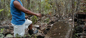
The existence of Uxbenka was first made known to the Belize Department of Archaeology as recent as 1984 when Mr. Placido Ash, the caretaker-guide at Nim Li Punit, came to the area following a report of looting near the village of Santa Cruz and found 
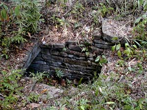
two sculpted 'stelae'. What he found during his survey of the site was one main plaza on the top of a hill with several smaller plazas at the base of the hill. There are six structures that surround the central plaza at Uxbenka. Reports say that seven 'stelae' were found, one dating back to the early classic period of the Maya.

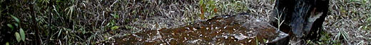
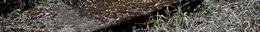
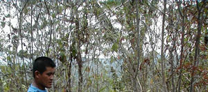
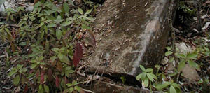
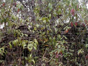
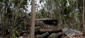
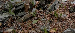
What Lester and I discovered the day we toured the site that baffled even this veteran explorer that laying in waste among the overgrowth of jungle tropical bush that now has overtaken the Uxbenka due to lack of funding for security, maintenance and further excavation were huge 'stelae' that had obviously been fallen by either vandals or by local villagers. The entire site is in dire straits, with a budget and some funding it could be a major Belize Maya archaeological that would take it off the beaten path and onto the tourist trail that would equate to providing an income for folks like Lester Cal and the other villagers. It might even provide reason enough for one cartographer thousands of miles away to pin point the correct location on a map. Maybe that's where the funding should begin, surly he makes enough off those maps to kick back some money to the Belize Maya archaeological sites. One thing that is clear not only to this explorer but more importantly to Lester Cal and the villagers of Santa Cruz, the treasures that lay silently outside the village on the hilltop of Uxbenka need to be addressed sooner than later.


Table of Content

previous page
next page